
An Ill Wind
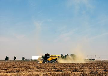
A combine harvests carrot seed in central Oregon, generating a large dust plume. This process illustrates how debris becomes airborne through field activities. (Photo courtesy of Kate Baldino, Oregon State University)
Smoke, pesticides, pollen, and the tiny microbes that cause carrot blight might not seem to have much in common. But with new mathematical models, ARS researchers are beginning to describe underlying patterns that govern them all as they move through the air. Their work may have far-reaching implications for agriculture – and beyond.
Walt Mahaffee is a research plant pathologist at the Horticultural Crops Disease and Pest Management Research Unit in Corvallis, OR. Together with colleagues from Oregon State University and the University of Utah, he has spent the last several years focusing his attention on how a tiny bacteria called Xanthomonas hortorum pv. carotae (Xhc) travels through the air. It’s a pressing question in central Oregon, which produces roughly half of the world’s supply of carrot seeds. The plants that produce the seed are vulnerable to the bacteria, which blights their leaves and flowers and reduces the quality and yield of carrot seed crops. Growers don’t have a remedy readily available, so their best defense is prevention.
A primary way to prevent the disease is with distance, planting carrots out of harm’s way – but how far is that? By comparing data on the actual spread of particles to their model’s predictions, Mahaffee and his colleagues are trying to provide ever-more-accurate answers for farmers.
“We don’t actually know exactly how it’s transmitted on the seed,” said Mahaffee, “but what we’re finding is that airborne debris during harvest is a potential source of inoculum for nearby fields. We’re developing an understanding of the type of particle, the fluid mechanics of the system, air turbulence – how it will potentially transport bacteria to the next year’s crop, because there’s a green bridge [a pathway for pathogen transmission via living plant hosts]. You have a green crop and a harvested crop co-existing at the same time, so the question becomes: how far apart do we have to have these in order to not contaminate?”
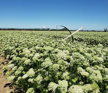
Flowering carrot plants in the springtime. (Photo courtesy of Kate Baldino, Oregon State University)
The research examines the combining process, when plants are separated into their parts – and seed is removed – via large mechanical sieve-like structures. The process tends to spray tiny debris particles from the plants into the air as they move through the machinery. By examining particles of different sizes, and comparing how far they can move, Mahaffee and his colleagues can provide farmers with estimates of how bacteria like Xhc could travel through their operations. It is, Mahaffee said, “a small component of a much, much larger effort to understand pathogen movement from leaf to regional and even continental scales.”
The project has brought some surprises, even for veteran researchers.
“We thought that the bacteria would be mostly on larger plant debris,” said Mahaffee, “and what we’re finding is that even on the very fine particles, we’re seeing significant bacterial numbers, and the finer the particle, the farther it can move.”
That kind of knowledge is crucial, because it interacts with many issues that farmers and researchers must consider – not only how far apart to plant crops, but also factors like wind conditions during harvest, topology, and the presence of nearby structures like trees, buildings, and hedgerows, among others. The bits of data that inform Mahaffee’s models are quite granular – collected every 60th of a second, measuring wind movement in three dimensions.
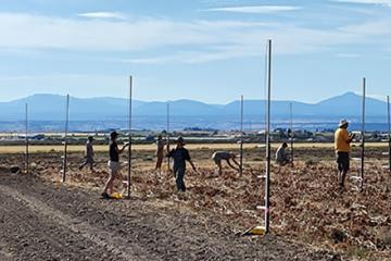
Researchers from the USDA, Oregon State University, and the University of Utah setting up towers that make up the particle release array in Madras, Oregon. (Photo courtesy of Walt Mahaffee)
Eventually, he said, the goal is to provide farmers with real-time data in the form of an interface – “a heads-up display system so that when you’re out in the field, the information is coming to you.” That system would pull in past weather data, forecasted weather, and climate data to provide a spatialized risk analysis of disease spread from known fields to potential planting locations.
In using such detailed models to inform farming practices, Mahaffee’s work adds to a growing movement toward precision agriculture, which seeks to optimize agriculture through precise, targeted application of data-based insights.
“The dispersion work could be foundational to the precision agriculture movement,” said Mahaffee.
In fact, he believes that carrot blight is really just the beginning. Improved understanding of airflow dynamics could also eventually help to explain the spread of everything from powdery mildew to pollution – anything that travels as an airborne particle. For now, though, the team is examining preliminary data, with an eye to refining models that could keep agricultural operations – and not their bacterial enemies – flowing smoothly. — Kathryn Markham, ARS Office of Communications