
A New Snowtography Handbook Puts Water Data into the Hands of Small Farmers and Ranchers
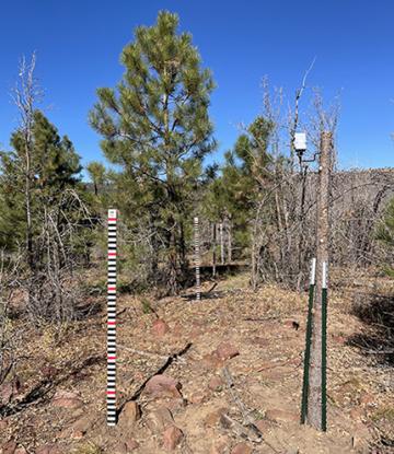
A snowtography transect crosses a clearing created by the severe Coon Creek Fire in 2000. This transect will capture the ongoing effects of the fire on snowpack. In the near right a camera is mounted facing the painted stakes. (Photo courtesy of Dr. Joel Biederman, USDA/ARS)
A new handbook, Snowtography: Snowpack & Soil Moisture Monitoring aims to put snowmelt and soil moisture data directly into the hands of ranchers, small farmers and other stakeholders in the western U.S. The handbook describes the importance of snow monitoring and provides easy-to-understand instruction on how to build and maintain a snow monitoring station using automated trail cameras.
“We want to build a network of snowtography stations but keep it in the hands of the stakeholders,” said Joel A. Biederman, a research hydrologist with the Southwest Watershed Research Center in Tucson, AZ. Biederman co-wrote the handbook with Elizabeth Payton of the Western Water Assessment, Cooperative Institute for Research in Environmental Sciences, University of Colorado, Boulder and Marcos Robles of The Nature Conservancy.
According to Biederman, western U.S. agriculture relies heavily on snowmelt for water resources. “Seventy to ninety-percent of western water resources in places like the Colorado River Basin and California’s Central Valley come from snowmelt,” he said. Monitoring the amount of water contained in the snowpack, and the timing of snowmelt, is crucial to the work of western ranchers, state or county land managers, U.S. forest personnel and others.
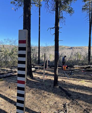
Dr. Jackson Leonard, Lead Scientist Sierra Ancha Experimental Forest, USDA-Rocky Mountain Research Station. A snowtography transect crosses from a mature ponderosa pine forest into a clearing created by the severe Coon Creek Fire in 2000. This transect will capture the ongoing effects of the fire on snowpack. (Photo courtesy of Dr. Joel Biederman, USDA/ARS)
Snowtography relies on time-lapse photography of painted sticks to determine snow depth. If the site is accessible during winter, the user can collect and weigh snow to reveal the SWE, or snow water equivalent. “Powder” snow may contain as little as 3% water, while heavy or packed snow may contain as much as 40% water.
The science is not new. Snow depth is regularly checked in the Sierra mountains via airplane and lasers, called LiDAR (though infrequent due to the expense). USDA’s Natural Resources Conservation Service (NRCS) has run the Snow Telemetry (SNOTEL) network since the 1980s. SNOTEL contains over 900 stations making hourly measurements of precipitation, snow depth and SWE across the West and Alaska. It’s the most widely used tool, come Spring, for predicting the amount and timing of snowmelt into aquifers, rivers and reservoirs, according to Biederman. But the SNOTEL data is only half of the picture.
“A key limitation of (SNOTEL) stations is that they are deployed in level clearings, not in forests,” said Biederman. SNOTELS don’t capture the effects of trees. In practice, snow accumulation and loss (due to evaporation, wind or melt) is heavily influenced by vegetation and complex topography.
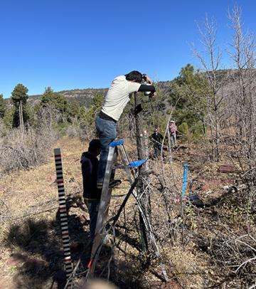
Dr. Ravindra Dwivedi, postdoctoral hydrologist with USDA-ARS, aims a trail camera to capture several graduated snowtography stakes. (Photo courtesy of Dr. Joel Biederman, USDA/ARS)
Combining information from SNOTEL with snowtography stations in forested areas will provide a better overall picture for western stakeholders as well as individual station owners. “Both methods are extremely valuable and complementary,” said Biederman. “But snowtography fills an existing gap in our understanding of how vegetation affects snow water resources.”
The snowtography stations can provide data on changing landscapes, according to Biederman. Recent wildfires are a perfect example. He said, “What are the impacts of fires that have occurred? We’re also getting a handle on how forest thinning to reduce wildfire risk affects snowpack. We’re learning how these vegetation changes impact the amount and timing of downstream water resources,” said Biederman. “If snow melts too early, that impacts reservoir operations and irrigation deliveries later in the summer. This new information will help us plan and prioritize our limited resources to get ahead of snowmelt.”
For more information about snowtography, or to learn how to build your own snowtography station, read the Snowtography Handbook.
For more information on the SNOTEL system, visit the National Resources Conservation Service Automated Snow Monitoring Page. — By Kelly A. Harmon, ARS Office of Communications