
Eyes in the Sky Keep Tabs on America’s Grazing Lands
ARS Scientists Provide Key Element to International Research Project
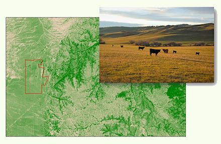
Agriculture has always been a very hands-on profession, but remote sensing – gathering information without making physical contact – is quickly becoming a major tool for ranchers for adaptive management.
Three ARS scientists are combining their education and experience with space-based technology and rangeland resources and turning their attention toward somewhere closer to home; Wyoming, Oklahoma, and Michigan, to be specific.
Feng Gao and Martha Anderson, research physical scientists at the ARS Hydrology and Remote Sensing Laboratory in Beltsville, MD, are members of an international team that is working to understand how grazing management decisions affect soil health on pasture and rangeland. Gao is a former NASA researcher at the Goddard Space Flight Center in Greenbelt, MD; Anderson has a doctorate in astrophysics. The third member of the team, Justin Derner, is a rangeland scientist and research leader at the Rangeland Resources and Systems Research Unit in Fort Collins, CO.
“We are using satellite remote sensing to map the biophysical properties of grazing lands, both native prairies and introduced forage pasture systems – properties like growing cycles, water use, amount of vegetation, and plant stress,” Anderson said. “These are all important indicators of vegetation health and productivity.”
The goal, she said, is to map those properties by combining data from sensors that use different spatial resolutions (digital image clarity), sensor wavebands (imaging wavelengths), and imaging frequency (from hourly to bi-weekly). “That kind of detail is required to get down to the scales of human influence and management of the land.”
According to Gao, near-real-time monitoring is required to improve grazing land management. “By providing near-real-time conditions of vegetation, ranchers may adjust their grazing strategy to improve cattle production and soil health,” he said.
Anderson said that, typically, ranchers must judge the results of their management practices by taking measurements on the ground – including soil moisture and carbon storage, water fluxes, vegetation condition, and local microclimate. However, these measurements usually represent only the local area.
“It’s hard to know how a whole pasture is responding to a different grazing strategy if you are only making point measurement in a small part of the pasture,” she said. “Satellite remote sensing data helps us scale up our measurements from point scale to the full pasture or multiple pastures. The data also give us information about variability across the pasture that may be missed by point measurements.”
Advances in technology give ranchers dramatic evidence of how effective their land management practices are. “We can make a timeseries of images, like movies, that show how these grazing lands respond to changing management practices by comparing paddocks that are managed in a business-as-usual way vs. adaptively managed,” Anderson said.
“There are metrics that identify indicators of healthy soils and vegetation, including soil carbon sequestration, soil fertility, soil structure, and moisture holding capacity,” she said. “Improvements in soil health can be manifest in above-ground signals – less water use, less plant stress, and more biomass – that we can sense via satellite.”
While the technology is advanced in terms of its use in this project, the platform is far from new. “One workhorse satellite is Landsat – a series of satellites first launched in 1972,” she said. “Landsat collects high quality data in optical and thermal wavebands, at 15 to 120-meter resolution, and gives us a unique record of changing conditions on the Earth’s surface.”
According to Gao and Anderson, they can apply to other areas what they learn in Wyoming, Oklahoma, and Michigan about connecting soil, vegetation, and ecosystem health to remote sensing signals. Remote sensing data can provide wall-to-wall maps that cannot be described by a traditional point sampling method. – By Scott Elliott, ARS Office of Communications
You May Also Like